Community-Based Flood and Glacial Lake Outburst Risk Reduction in Nepal
Summary
A joint initiative of the government of Nepal, the United Nations Development Program (UNDP), and the Global Environment Facility (GEF) this project had the objective to reduce human and material losses from Glacier Lake Outburst Floods (GLOF) in the Solukhumbu district, and catastrophic flooding events in the Terai and Churia Range of Nepal.
Given its geographical characteristics, Nepal is a country facing numerous natural hazards of geological and climatic origin, which under the current circumstances of climate change represent an imminent and increasing danger to the well-being of the local population and their livelihoods. With the increase in average annual temperatures and the retreating of glaciers, one of the main threats is the possibility of GLOFs due to the formation and expansion of glacial lakes; in fact, according to an earlier report by ICIMOD (2011), 21 glacial lakes in the country have already been identified as potentially dangerous, and six of them as highly risky. At the same time, with the rising frequency of extreme precipitation events, floods and flash floods are also adding to the impacts affecting certain regions. This project then addressed these two risks in four Terai districts and the Solukhumbu district. Conducted at 5,010 meters’ altitude, it is known as the world’s highest altitude climate adaptation project.
The undertaken actions were divided into two different components with non-interconnected activities, including the development of early warning systems (EWS), monitoring, development of programs to respond to floods and GLOFs, and local awareness raising.
- Outcome/Component 1 – Reduce GLOF risks arising from Imja Lake
- Outcome/Component 2 – Reduce human and material losses from recurrent flooding events in flood-prone Terai districts
Overview
- Location:
- Implementation sites:
-
- Single country
- Multiple locations
- Mountain region:
-
Himalayas, Terai, and Churia ranges
- Province:
-
- Udayapur, Siraha, Saptari, Mahottari, and Solukhumbu districts
- Site locations:
-
Imja Lake, Terai districts
- Ecosystem type(s):
- Solution type(s):
- Climate impact(s) addressed:
- Other climate impact(s) addressed:
-
- GLOF
- Climate impact time-scale(s):
- Main benefit associated with the solution:
- Co-benefit(s) associated with the solution implementation:
- Implementation timeline:
-
- 2013 - 2017
- Sendai targets:
-
-


- SDGs:
-
-
Solution details
Main beneficiaries & outcomes
The direct beneficiaries of Component 1 (GLOF) include the 12,690 inhabitants residing in the high-risk settlements located within the 50 km downstream of Imja Lake, while Component 2 (flood) benefited about 59,062 inhabitants from eight Village Development Committees (VDCs) in the Terai district. Although benefits are widespread in the implementation areas, a gender strategy was put in place to ensure the active participation and representation of women and other socially excluded and vulnerable people in project activities and decision making. Also, structures such as gender-friendly toilets were built in evacuation centers to improve women’s access to safe sanitation facilities during emergencies, and two disabled-friendly elevated tube wells were put into operation to facilitate their access to safe drinking water.
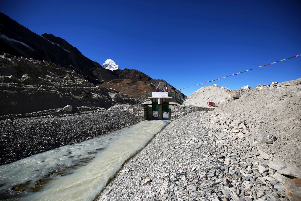
Some of the key results include reduction of the water level of Lake Imja through controlled drainage, development of 18 safe evacuation centers, implementation of community-based early warning systems, 7.4 km of flood-proof drainage systems, elevated tube wells, operational hydromet and GLOF sensors, sediment control and stabilization of risk-prone slopes and riverbanks through structural and non-structural mechanisms, training in flood risk management and GLOFs, conducting of 52 drills, generation of GLOF risk monitoring protocols, and formation, equipping and training of local disaster risk management committees.
Planning and implementation
With the UNDP as implementing agency, the project was implemented under the National Implementation Modality and executed by the Department of Hydrology and Meteorology (DHM) in close collaboration with the Ministry of Population and Environment (MoPE), the Department of Water Induced Disaster Management (DWIDM), the Department of Soil Conservation and Watershed Management (DSCWM), the Department of National Parks and Wildlife Conservation (DNPWC), and other relevant stakeholders.
Design of the solutions was elaborated in accordance with the priority areas of the National Adaptation Program of Action (NAPA) on climate change, through consultations with government partners engaged in climate risk management, government glaciologists, hydrologists, and GLOF experts, while the selection of the target areas was based on previously conducted vulnerability assessments. Moreover, further consultations were also conducted with local communities, community-based organizations and non-governmental organizations from the targeted areas.
Finance
The major source of funding to the project resulted from the Least Developed Countries Fund (LDCF) managed by Global Environment Facility (GEF) and UNDP. Further details are described next:
|
Finance |
Total (US$) |
|
Total project finance: |
7,568,430 |
|
GEF-LDCF Financing: |
6,300,000 |
|
UNDP (in-cash): |
949,430 |
|
UNDP/TRAC (in-cash): |
319,000 |
|
Total Co-Financing: |
19,403,080 |
|
UNDP (CDRMP) (in-kind): |
7,682,900 |
|
NRRC (parallel co-financing): |
2,857,811 |
|
Govt. Nepal/DWIDP (In-kind): |
7,000,000 |
|
USAID-ADAPT ASIA (parallel co-financing): |
157,369 |
|
ICIMOD (parallel co-financing): |
1,705,000 |
|
TOTAL ALLOCATED RESOURCES: |
26,971,510 |
No cost-benefit analysis was conducted.
Innovation
The lowering of the water level in Lake Imja at such a high altitude (in the lap of Everest) can be considered a remarkable aspect of this project as it required new technology and specific methods for which only a few experts worldwide have the necessary know-how to supervise the activities. In addition, another innovative feature was the use of the pioneering approach of bringing together science, institutions and society. According to the project reporting, the close work with local communities to whom the necessary tools and knowledge to manage and direct risk prevention activities were provided, have proven beneficial in the region.
Performance evaluation
The project’s performance was assessed through a mid-term evaluation conducted in May 2016, as well as a final evaluation (TE) conducted in November 2017 by UNDP. The TE included interviews with multiple partners and key stakeholders at community, district and national levels, as well as two field studies in Terai and Solokhumbu districts. The relevance, effectiveness, efficiency, impact, and monitoring and evaluation of the project were assessed, along with the likelihood of sustainability of project results. Qualitative and quantitative methods were used. Overall, the project was rated as satisfactory.
Long term project sustainability and maintenance
The sustainability of the project results has been considered in the TE as ” Likely”, with negligible risks. Although there are still some uncertainties regarding financial support for maintenance activities in the future, the Early Warning Systems installed in the participating communities were initially designed to require minimal maintenance works. Moreover, the appropriate protocols, training and skills to carry out the monitoring and maintenance tasks have been handed over to local government agencies and communities to facilitate continuity. In this case, the Ministry of Population and Environment (MOPE) has shown its commitment and, together with the hydropower providers, has expressed its willingness to extend financial support for these purposes. On the other hand, community members and groups have taken ownership of both elevated tube wells (easily maintained by local technicians) and emergency shelters.
Capacities for design and implementation
Knowledge
Existing knowledge about the state of glacial lake Imja and the conditions of vulnerability of the local communities proved to be one of the most useful aspects during the design and implementation of measures. Similarly, the experience of key stakeholders was also very helpful; for example, DHM already had some experience in lake drawdown, gained from conducting these types of activities on the Tso Rolpa glacial lake in 2000. Although a much smaller lake, it provided relevant lessons and also encouraged an emphasis on community participation.
The experience of other partners, such as UNDP, which has extensive knowledge regarding community-based disaster risk management programs, was also useful. ICIMOD and Kathmandu University provided guidance on technical issues.
Technology
Technology related to the installation of early warning systems has been of help for the project. Based on the Tsho Rolpa Lake experience, where the systems implemented were considered a failure because they were too technologically advanced, and to avoid long-term sustainability issues linked to maintenance costs, the solution focused mainly on the use and application of low-cost technologies. Sirens and GLOF sensors using iridium and telecommunications have been installed to trigger warnings in case of hazardous events, and hydro meteorological stations were also established.
Political / Legal
The proposal and implementation of this project was the result of a clear interest of the national government of Nepal to support the priority interventions identified in the National Adaptation Programme of Action on Climate Change (NAPA). The covered solutions contribute to NAPA Combined Profile 3, “Community-based disaster management to facilitate climate adaptation”, and Combined Profile 4, “Extreme weather monitoring and disaster risk reduction”. Furthermore, they are also consistent with national disaster risk reduction objectives.
Institutional
Throughout the process of designing and implementing the solutions, there was close collaboration between the Department of Hydrology and Meteorology (DHM) as implementing entity, with the UNDP and GEF, as well as with DWIDM, DSCWM, DNPWC, ICIMOD, Kathmandu University (KU), Tribhuvan University (TU), and the local community groups. Such collaborations proved very useful in enriching the project, promoting resilience and ensuring sustainability.
For the coordination of activities, the project had three organizational levels:
- Project Steering Committee – lead by MoPE with representation from the relevant government entities, civil society groups, local private sector, ICIMOD, KU, TU and other stakeholders.
- Project Executive Board – It functioned as the decision making body and was chaired by the Director General/ National Project Director, and the DHM.
- Technical Advisory Group (TAG) – an eight-member group that provided technical inputs and strategic guidance to the project.
Additionally, a Field Coordination Office (FCO) was also created on the Siraha district to manage the field activities under Component 2.
Socio-cultural
Consultations with local community members, community groups and NGOs significantly shaped the project from the initial stages through the significant feedback provided. Later, these important stakeholders (including women and members of marginalized communities) were also actively involved in awareness-raising activities, trainings, mock drills and even infrastructure-related works. They have learned the necessary skills and knowledge on prevention and reaction to hazardous events, as well as on the operation and maintenance of early warning systems. In addition, the population has demonstrated its commitment to the project and 8 local disaster risk management committees and 35 community development management committees have been formed and trained.
Outlook & Scalability
Barriers and adverse effects
Previous to the execution of activities, insufficient institutional knowledge and capacity at the DHM to understand and manage GLOF risks was identified as one of the main barriers. This was successfully overcome thanks to the capacity building efforts undertaken and DHM, the Nepalese Army and other partners, all of whom have now improved capacities for conducting similar projects in the future.
Other challenges related to the financial needs of the project, due to the economic blockade by India following the Gorkha earthquake in 2015, which resulted in a major strain on various sectors and impacted the project as the construction works for the Imja Lake were escalated, leading to an increase of USD 0.8 million from the original estimated cost.
Transformation and future outlook
These solutions significantly improved the knowledge and skills needed by government, private and social actors to address the imminent risks that the local communities in the five participating districts face in relation to flooding and GLOF events, and which, according to climatic information, are likely to increase in the future as a result of rising temperatures and climate variability. By improving practical and non-practical knowledge in the project areas, the understanding of these types of events has been improved and the vulnerability and exposure of communities could be considered as having been reduced.
Potential for upscaling and replication
In line with the project design, it is intended that both the lessons learned and the skills and capacities developed among local stakeholders and population will enable future replication and/or scaling up of the solutions. Moreover, this is expected to be further facilitated by the fact that the technologies put in place are low cost and easy to maintain by the communities. In the case of glacial lakes, the experience gained at Imja Lake could be useful for carrying out similar activities at the other five glacial lakes considered to be of high risk (those identified by ICIMOD in 2011).
Comments
There is no contentYou must be logged in to reply.