Nursing trees for tilted farming in Burundi
Summary
The Climate-Resilient Altitudinal Gradients (CRAG) project, from which this solution is part, was initiated in 2017 with the objective of strengthening local ecosystems as a means to improve resilience in a number of communities located at elevations above 1000 meters above sea level in the highlands of north-western Burundi. It aimed to decrease erosion and landslide risk through the adoption of sustainable agricultural practices on steep slopes.
Many farmers practice their living on the exposed steep hills of the Lake Tanganyika Basin in north-western Burundi, areas that are facing a heightened risk of soil erosion and landslides as a consequence of both climatic and human factors. With increased heavy precipitation events on the one hand, and population growth combined with unsustainable agricultural practices on the other, vulnerability to erosion, landslides, and food insecurity on these hillsides is expected to increase. This soil runoff has a negative impact on nearby rivers by adding sediment that increases turbidity and drains agricultural soils of nutrients, reducing their fertility.
One of the adaptation solutions derived from the CRAG project was the agroforestry approach to agriculture, which consisted of interventions based on a nature-based solutions approach, considering the reciprocal relationship between people and the environment they inhabit to find ways of co-development. Thanks to the CRAG project, more than 200 farmers have planted trees alongside their crops to improve the degraded vegetation on these hills and protect the exposed soil. As the trees grow, they form barriers against rainwater running down the slopes, making the soil less able to move and limiting the drainage of its nutrients. Also, by developing root systems, trees create stronger connections deeper in the soil, which greatly reduces the risk of landslides.
Overview
- Implementation sites:
- Multiple countries
- Single location
- Mountain region:
- Highlands in north-western Burundi
- Site locations:
Ruhwa and Muhira catchments
- Solution scale:
- Ecosystem type(s):
- Solution type(s):
- Climate impact(s) addressed:
- Impact time-scales:
- Co-benefits:
- Implementation timeline:
- 2017 - 2019
- Sendai targets:

- SDGs:
Solution details
Main beneficiaries & outcomes
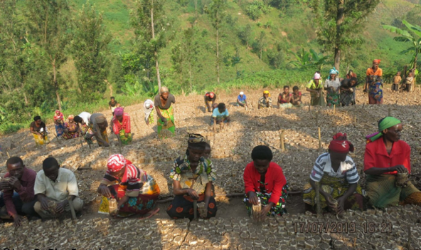
Beneficiaries of the solution include at least 267 community members in the Ruhwa and Muhira catchments of Lake’s Tanganyika basin who engaged in setting up tree nursery beds with 834,000 seedlings. Several of these community members also benefited from NBA workshops, resulting in increased awareness and knowledge about climate change and the correct implementation of sustainable adaptation measures.
In the communes of Murwi and Mugina in Cibitoke province, communities received 5,000 fruit trees, the planting of which will have positive effects on the local environment through carbon sequestration and soil retention. Furthermore, it contributes to protecting the local population from natural disasters such as landslides and floods and can provide them with additional income.
Planning and implementation
The CRAG project was developed by BirdLife International with support from the MacArthur Foundation as part of the Great Lakes Conservation Strategy. In close collaboration with local communities, the initiatives described here were led in conjunction with the Association Burundaise pour la Protection de la Nature (BirdLife’s local partner).
The project adopted a community-oriented approach from the outset, which was established through regional workshops organized by ABN where Site Support Groups (SSGs) were formed. In these workshops, ABN met with 53 community members to map out the environmental problems they faced and identify corresponding solutions. Field visits were also conducted and soil samples were taken. Integrating the project beneficiaries was essential to ensure that the project addressed the relevant problems faced by the community and to ensure strong ownership of the activities and results.
Finance
The project was financed by a grant from MacArthur Foundation with additional support from the Nature Conservancy (TNC).
Innovation
The innovative aspects of this solution are related to the fact that the CRAG concept contains location-specific elements and that local communities were involved in all phases of the project, from site identification and stakeholder mapping to soil sampling and tree planting. Measures such as agroforestry can inspire projects in other countries and regions with steep topography to undertake similar sustainable actions. In addition, ecosystem-based climate adaptation has the potential to produce multiple benefits for the environment, biodiversity, and local communities.
Long term project sustainability and maintenance
The long-term sustainability of project results is sought through the generation of ownership of project results and activities by the communities. The engagement and empowerment of local people increase the likelihood that they will maintain their interest in the well-being of their ecosystems in the future and continue to use the ecosystem-based soil adaptation and conservation techniques that were taught by the experts during the workshops and training activities. For instance, during the meetings held, participants agreed to share information about the CRAG approach within their professional networks to encourage its acceptance and subsequent implementation.
Capacities for design and implementation
Knowledge
The knowledge and experience of BirdLife and collaborating organizations were critical in assessing baseline conditions in the project areas. Sediment sampling was conducted based on drainage, local knowledge, and watershed boundaries. While soil sampling was conducted based on geological types. These two different samplings (soils and sediments) were subsequently used to determine the chemical compositions of the elements and, together with the climate change vulnerability assessments for local communities, generate a map identifying locations and actions for interventions.
Technology
Available technologies, such as GPS location (pre-calculated in ArcMap software) and X-ray spectrometry, were used for the collection and analysis of soil samples. With this information, models were produced showing the contribution to river sedimentation by type of geology and sub-basin and mapping potential erosion and sedimentation hotspots in the region.
Institutional
BirdLife International’s institutional capacities and skills were very important to the management of the CRAG project. Leveraging partnerships not only with local institutions and government but also with community groups facilitates the design, implementation and overall success of projects. In the case of this solution, this enabled the implementation of this second phase of CRAG in the region.
Outlook & Scalability
Potential for upscaling and replication
Although the activities described in this article only describe those carried out in Burundi, the CRAG project was also carried out in neighboring Rwanda and Uganda, again funded by the MacArthur Foundation.
(0) Comments
There is no content