Using Unmanned Airborne Vehicles (UAV) for glacier monitoring in the Himalayas
Summary
This project was implemented from May 2014 to January 2016 in the Langtang and the Everest regions in Nepal for improving the understanding of the contribution of large debris-covered glacier tongues to regional hydrology.
Glaciers in the Himalayas are of fundamental importance for upstream and downstream communities in the region. Through the seasonal melting of water, they feed some of the largest river systems in the world and provide water for human consumption, agriculture, energy production, and other industries. For decades, the scientific community has been working towards a better knowledge of the state and dynamics of such glaciers. However, debris-covered glaciers have remained relatively unstudied due to their difficult access for field studies. Despite the fact that satellite remote sensing can help in such cases, a lower image resolution and limited accessibility still causes certain challenges and limits the acquisition of quality data. Using Unmanned Airborne Vehicles (UAV) then represents an opportunity for addressing such issues by allowing the execution of fieldwork with reduced risks, and by providing higher resolution imagery.
The “Using Unmanned Airborne Vehicles (UAV) for glacier monitoring in the Himalayas” project consisted of three successful missions at the Lirung and Langtang glaciers in the Langtang region, and in the Changrinup glacier at the Everest region.
The project general was considered highly successful due to the effective work of the consortium formed by Utrecht University, ICIMOD, and FutureWater, as well as the informal collaboration with numerous other scientific groups and actors. Outcomes included the provision of highly accurate and detailed datasets, scientific papers, and a professional documentary, as well as awareness-raising on the relevance of this type of technology for other future scientific purposes.

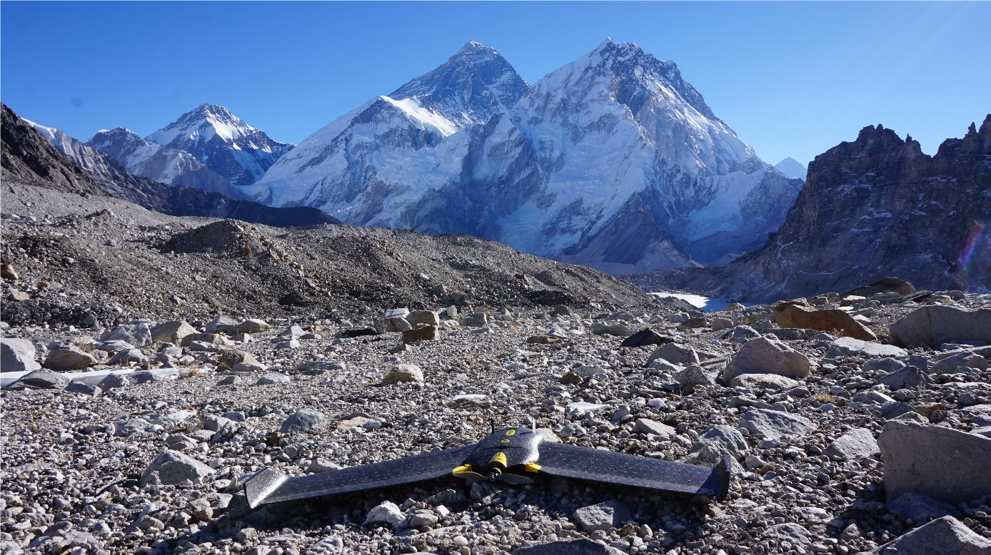
Launching the eBee. Photo obtained from the Project’s Final Report.
Overview
- Location:
- Implementation sites:
-
- Single country
- Multiple locations
- Mountain region:
-
The Himalayas
- Province:
-
- Langtang region, Everest region
- Site locations:
-
Lirung and Langtang glaciers in the Langtang region, Changrinup glacier at the Everest region
- Solution scale:
- Ecosystem type(s):
- Solution type(s):
- Sector(s):
- Climate impact(s) addressed:
- Climate impact time-scale(s):
- Main benefit associated with the solution:
- Co-benefit(s) associated with the solution implementation:
- Implementation timeline:
-
- 2014 - 2016
- Sendai targets:
-
-


- SDGs:
-
-


Solution details
Main beneficiaries & outcomes
The scientific community can be considered the main beneficiary of the project accomplishments, as it proved the use of UAVs as an innovative solution for studying debris-covered glaciers more accurately and provided new and useful scientific information. The three missions carried out resulted in three high-quality open access scientific papers, interactive 3D models based on the UAV datasets, several publicly available datasets, and a professional documentary aiming to illustrate the use of these novel measurement techniques for studying the response of Himalayan glaciers to climate change. Likewise, researchers also benefited from a new semi-automated object-based approach to automatically classify ice cliffs and ponds with high accuracy and which has a wide field of application.
Other beneficiaries of the solution comprised numerous other stakeholders who were incorporated in different project-related activities. Some of them include various representatives from DFID, The Nepalese army, the Civil Aviation Authority, the police, ICIMOD, Utrecht University, Nepal Academy of Science and Technology, The Department of Hydrology and Meteorology, Kathmandu University and, the Tribhuvan University who profited from a workshop organized on January 2015 in the use of UAVs in different fields. At the same time, students from the Himalayan region saw their skills and experience enhanced by their inclusion in the project research and participation in the Training on Glaciohydrological Monitoring and Modelling hosted by ICIMOD and sponsored by the American Embassy in Kathmandu.
Finally, and given their location and living circumstances, local communities equally beneficiated from the knowledge and awareness generated under this solution. Policy recommendations were made for governments in the region including the creation of a reasonable approach to facilitate the applications of UAV technology for scientific purposes, and the implementation of an international benchmark glacier monitoring program at representative sites in the Himalayas where UAV mapping is conducted annually to generate long-term time series of changes in glaciers. Moreover, by gaining an accurate estimation of the conditions of the surrounding glaciers, the local population have also the opportunity not only to predict future water availability under the current climate change trends, but for assessing related natural risks and adjust their livelihoods accordingly.
Planning and implementation
The planning and implementation of this project were partially inspired by the previous performance of a ground-breaking pilot project on the debris-covered Himalayan Lirung Glacier using a UAV (Immerzeel et al., 2014) in 2013 by Utrecht University, ICIMOD, and HiView (a spinoff of FutureWater dedicated to scientific applications of UAVs), which, among other outcomes, demonstrated the potential of this type of technology and method for routine monitoring of debris-covered glaciers.
The execution of the project was under a consortium comprising of Utrecht University, ICIMOD, and FutureWater. With the use of an eBee Unmanned Aerial Vehicle from the Swiss company SenseFly, flights were performed during the three missions with an approximate duration of 30 minutes each. Thanks to the camera and GPS incorporated in the vehicle, numerous overlapping pictures of the glaciers’ surfaces were acquired and highly accurate GPS measurements were collected, allowing for geometric correction of the image locations during processing. Later, digital elevation models were elaborated by using the photogrammetrical algorithms of the Agisoft Photoscan Professional software package, and 10 cm/pixel stitched and georeferenced images (known as an orthomosaic) were created. In addition, the various datasets resulting from the field studies also served for the subsequent development of 3D models using the SketchFab software package.
Finance
The project was funded by UKaid from the UK Government, and partially supported by core funds of ICIMOD.
Innovation
Over the last decade, the use of Unmanned Aerial Vehicles for glacier monitoring and assessment purposes has emerged as a highly innovative and effective approach that is transforming the way in which research in the field is done. This new technique not only reduces field work-related risks for researchers, but also allows to overcome some of the limitations of satellite remote sensing such as accessibility, ownership, accuracy, and image resolution, in particular for the case of debris-covered glaciers. Furthermore, the project tested the use of UAVs at high altitudes with success (up to 5900 meters above sea level).
According to the project’s final report, this solution has a huge potential for climate change impact research as the technology and methods related to UAVs are now at a stage where they can be used for routine monitoring, enabling a better understanding of the response of the Himalayan glaciers to a changing climate.
Performance evaluation
There is no available information regarding the conduction of a performance or impact evaluation under the frame of this project.
Long term project sustainability and maintenance
There is no information related to maintenance activities carried out during the lifetime of the project.
Capacities for design and implementation
Knowledge
Knowledge played a key role in the planning and implementation processes of the project. First, the previous pilot project conducted by the Utrecht University, ICIMOD, and HiView in 2013 rendered significant information in the use of Unmanned Aerial Vehicles on a debris-covered glacier that later served as an example for this project. Moreover, the execution of this innovative solution was only possible thanks to the scientific and technical knowledge and expertise of the project’s members and researchers in charge of fieldwork. Such knowledge was useful for both the adequate employment of the vehicles and the analysis and study of the gathered data.
Technology
Until recent times, the employment of satellite remote sensing remained the most efficient way for obtaining images of the glaciers’ surfaces and a common approach when studying debris-covered glaciers. However, their use is often limited by the fixed time at which images can be acquired and a low image resolution of about 30m/pixel. For this reason, the technological advancement and appearance of high-performance UAVs for professional scientific use constituted a consequential change in practice. It was a fundamental enabler of the successful development of this project thanks to the provision of very high-quality images (~ 10 – 20 cm/pixel resolution) that allowed for studying of key processes that occur at the surface of the glacier. Furthermore, within the frame of the project, researchers successfully pioneered the use of the UAVs at high altitudes (up to 5700 meters above sea level) after some modifications to the device.
Political / Legal
Governmental actors provided economic support for the project. Through the UKaid fund, the Government of the United Kingdom contributed with the main financial allowance, while numerous governments provided core funds for ICIMOD. Additionally, some authorities from the Nepalese police, army, Department of National Parks and Wildlife Conservation, and the Civil Aviation Authority also were crucial in providing permits to fly the UAV, and participated in a workshop organized in January 2015 at ICIMOD (Lalitpur, Nepal). Such a workshop had great success at raising awareness and creating interest in the project, and also helped secure the permits for executing the research. Permits are necessary not only because special permits are required for flying UAVs, particularly in sensitive border regions, but also because the research area was located in a National park.
Institutional
Various informal collaborations were made during the execution of the project and later data analysis. In the case of the Everest region, collaborations took place with Dr. Patrick Wagnon (IRD France/ICIMOD), Dr. Christian Vincent (LTHE France), Dr. Dibas Shrestha (Nepal Academy of Science and Technology), and Ms. Alexandra Giese (Ph.D. student, Dartmouth) for obtaining field datasets of glacier ice thickness, glacier melt and surface profiles from the Changrinup glacier that could be combined with data from the UAV. Likewise, the project’s members also collaborated with a Japanese group of scientists for using the UAV over the Langtang village and mapped the extent of the damage that was caused by a 7.8 magnitude earthquake that struck the area in April 2015. With this, researchers tried to reconstruct the causes and the volume of ice and debris that was deposited on the village after an avalanche was produced.
Socio-cultural
There is no information provided regarding the participation of local communities in the project.
Outlook & Scalability
Barriers and adverse effects
One of the main problems during the implementation of the project was the earthquake occurring on 25th of April 2015. Given that a second field work planned for the week after the earthquake could not take place, the project was delayed and generated additional costs. However, this problem was overcome with the support of the project officer of the South Asia Research Hub of the UK Department for International Development. On the other hand, the use of the Unmanned Aerial Vehicle was also challenging due to the need for a special permit for flying in the National Park, as well as the difficulties of flying it at very high altitudes where the air is very thin and causes it to fly faster and less stable. Nevertheless, the permit problem was solved thanks to the aid of the local authorities, while the flying difficulties were conquered by the device manufacturers who made modifications to the vehicle.
Transformation and future outlook
Because of the relatively low operational costs, availability, performance, and low risks, the utilization of Unmanned Aerial Vehicles has a huge potential for future glaciological research. For example, it brings a unique opportunity for the long-term monitoring of both debris-covered and debris-free glacier’s surfaces that would improve the assessment of the changes produced by climate change on these environments and their impacts for surrounding communities. Moreover, UAV technology is a rapidly advancing field. Thermal cameras are now available for eBee vehicles, permitting to better quantify melting and evaporation processes and estimate debris thickness. All these characteristics may also be very useful for related aspects such as a better planning on development, agriculture, irrigation scheduling, and the identification of crop diseases.
Potential for upscaling and replication
The methods and approaches from this project served as the basis for continued studies of glaciers in Langtang (Nepal) using UAVs. Further studies have been funded by the Climate-KIC programme of the European Institute for Innovation and Technology (https://www.climate-kic.org/), with a brief summary available at https://mountainhydrology.org/projects/icespy/. ICIMOD is well-placed institutionally to replicate and upscale such activities beyond Nepal to other Himalayan regions.
Comments
There is no content