Management and conservation of wetlands and paramos in Venezuela: Successful experiences of adaptation to climate change in the Mixteque – Mérida paramo
Summary
Implemented in the community of Mixteque, in the municipality of Rangel, the solutions described here were promoted by local communities and their organizations and were intended to improve the management and conservation strategies of wetlands and paramos for preserving water availability in the region. They were supported by the Paramo Andino Project (PPA) as well as other initiatives and actors.
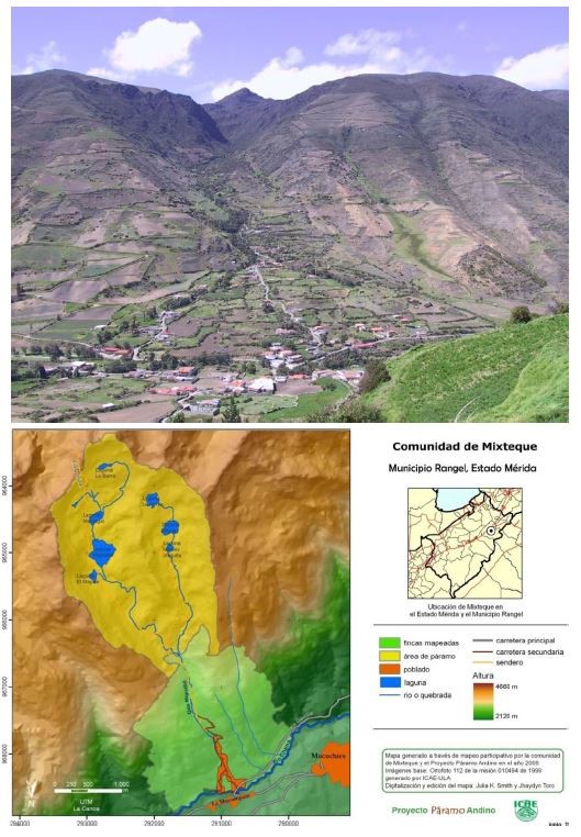
The paramos (moorlands) of the Mixteque micro-basin, like other Venezuelan paramos, represent important socioecosystems that provide multiple ecosystem services to local populations, including water regulation and supply, both for ecosystem function and to meet the need for vital resources and agricultural activities on which most local livelihoods depend. The expansion of the agricultural frontier, intensive grazing in pastures and extensive grazing in the high Andean zone, in addition to the intensive use of agrochemicals and synthetic fertilizers, threaten the integrity and ecosystemic functionality of paramos, wetlands, lagoons and forest remnants, which in turn affects water retention and storage capacity, while impacting the quality and availability of such resource, especially in the dry season. This problem is intensified by the effects of climate change, characterized by increased temperatures and reduced rainfall, which will produce ecosystem changes that can further reduce the regulation and storage capacity paramos.
Considering that the availability and quality of water are key factors that affect the vulnerability and adaptive capacity of local livelihoods, the communities in the area, which have a long tradition of social organization, have been implementing a series of actions focused on preserving the availability and quality of water, such as the fencing and protection of springs and control of the pressure of extensive grazing by cattle and horses in paramos and wetlands. These initiatives have been strengthened by interventions from other institutional actors, including the regional Paramo Andino Project (PPA), which supported the consolidation of a series of participatory strategies for community water management and administration, namely hydrometeorological monitoring, participatory mapping and zoning, and strengthening the fencing of wetlands for ecosystem rehabilitation (many of which have been maintained over time).
The applied CCA strategies with the greatest impact on biophysical-environmental aspects of the paramo and wetland socioecosystems, as well as on the agricultural systems, include participatory hydro-meteorological monitoring (MHMP), wetland fencing, and rotational grazing.
(Por favor consulte el documento adjunto para la versión en ESPAÑOL)
Overview
- Location:
- Implementation sites:
-
- Single country
- Single location
- Mountain region:
-
Northern Andes
- Province:
-
- Merida State
- Site locations:
-
Rangel Municipality
- Solution scale:
- Area Covered:
-
- 10.5 km2
- Ecosystem type(s):
- Other Ecosystem type(s):
-
- paramos
- Solution type(s):
- Other sector(s) type(s):
-
- extensive grazing
- Climate impact(s) addressed:
- Other climate impact(s) addressed:
-
- ecological degradation of moorlands
- Climate impact time-scale(s):
- Main benefit associated with the solution:
- Co-benefit(s) associated with the solution implementation:
- Implementation timeline:
-
- 2007 - 2019
- Sendai targets:
-
- SDGs:
-
-
Solution details
Main beneficiaries & outcomes
Beneficiaries to the solutions include approximately 730 direct beneficiaries of the Mixteque community, who depend on the water generated in the micro-watershed. Additionally, there are also 5991 and 19634 indirect beneficiaries in the capital parish of Mucuchíes and the municipality of Rangel, respectively.
The beneficiary population consists of peasant-mestizo communities whose livelihoods are based mainly on agricultural activities, paid off-farm agricultural work, commerce, construction and transportation. Because of its proximity to the capital parish of Mucuchíes, the inhabitants of Mixteque have good access to basic health services, sanitation, and basic and university education. Mixteque’s population is characterized by high levels of participation and organization, especially in irrigation committees and producer groups, which has allowed most producers to have access to drinking water and sprinkler irrigation.
Initiatives for the management and conservation of paramos and wetlands, including the fencing and exclusion of cattle or the management of community vermiculture, have been led by two female community leaders, ecologists and popular educators, Ligia Parra and María Vicenta Dávila, whose work was strengthened by the interventions of the PPA, in which these women leaders continued to lead.
Planning and implementation
Environmental Coordinators Association of the Municipality of Rangel (ACAR): Local organization that leads initiatives for the protection and rehabilitation of wetlands through their partial or total enclosure/fencing to exclude cattle and horse grazing, while promoting their rehabilitation through reforestation with native paramo species.
Andean Paramo Project (PPA): A regional initiative that worked for the conservation and sustainable use of the paramos of Venezuela, Colombia, Ecuador and Peru. It was led by the Consortium for the Sustainable Development of the Andean Ecoregion (CONDESAN) with different implementing partners in each country. The PPA was financed by the Global Environment Facility (GEF) through the United Nations Environment Program (UNEP). The PPA provided technical and financial support for many of the initiatives for the management, conservation and monitoring of the paramos and wetlands, as part of the strategies in the Mixteque-Gavidia pilot site.
Institute of Environmental and Ecological Sciences of the Universidad de los Andes (ICAE): Executing partner of the PPA in Venezuela. It has been providing technical and academic support to the community since the PPA, in the socioeconomic-environmental assessments, involving as well professors and students in the research processes such as participatory mapping/zoning, hydrometeorological monitoring, water balances, analysis of the impact of grazing exclusion practices in wetlands, rotational grazing and ecosystem rehabilitation.
Irrigation committees: strategic actors at the local level, whose own initiatives for paramo conservation and wetland fencing, mainly focused on guaranteeing water availability and quality for users in the middle and lower part of the micro-watershed, have been the basis for the development of other adaptation initiatives in the micro-watershed and motivated participation and replication in other communities in Venezuela, such as Gavidia and Túname.
Community Councils: Organizational bodies of the local population promoted by the State to facilitate local participation in the planning and execution of public policy. They have been the link between the executing and implementing bodies and the community, allowing for better participation and involvement of the local population in the different CCA initiatives.
Small agricultural producers and other community members: Direct beneficiaries who have received technical assistance, training, equipment and infrastructure as part of the adaptation measures agreed and prioritized through participatory processes.
Finance
The GEF through UNEP was the main funding entity for the different CCA initiatives that the PPA designed and implemented in Mixteque. Approximately 50,000 USD were invested, half of which was allocated for research and equipment activities (installation of the hydrometeorological and water balance monitoring system, ecosystem rehabilitation, participatory mapping/zoning, controlled rotational grazing in pastures), and the remaining half in the implementation of different CCA practices (support for some wetland fencing activities and impact assessment, paramo and hillside restoration with native species, agroecology, prevention of soil and water contamination through the recycling of agrochemical containers and pilot wastewater treatment plants, recovery of traditions and cultural identity focused on ecotourism processes).
It is important to emphasize that the local population, especially through the irrigation committees, have led the wetland fencing activities, financing the participation of community members (mobilization, labor, food) and providing fencing materials (wooden posts and barbed wire).
Innovation
The most relevant innovative aspect of CCA initiatives in Mixteque has been the involvement of the local population in the planning, analysis, design, implementation and monitoring of the different adaptation measures identified and prioritized through participatory processes that involved key actors at the local, national, public and private levels. These included irrigation committees, community councils, producer groups, NGOs ( Popular Education Center for the Integral Development of the Family (CEPDIF), ACAR, Integral Producers of the Paramo (PROINPA), local educational institutions (school and college of Mixteque), academia (ICAE), public entities (National Institute of Parks of Venezuela (INPARQUES), and the Ministry of People’s Power for the Environment (MOPE), and the National Institute of Parks of Venezuela (INPARQUES); Ministry of People’s Power for the Environment (MINAMB); Ministry of People’s Power for Agriculture and Lands (MPPAT), Municipality of Rangel) and the PPA. This participatory space for planning, design and implementation was mainly reflected in the mapping and zoning processes, and in the hydrometeorological monitoring of the páramo and wetlands.
Participatory mapping and zoning is a method for collecting and mapping agricultural and socio-economic information at the farm and community levels. For this purpose, collective workshops are organized in which participants have the opportunity to directly delimit their farm boundaries and their internal sectorization, using large-scale printed remote imagery. The maps obtained are then used to collect detailed and sectorized information (through agricultural and quality of life surveys) on the different socio-economic-productive aspects of each farm and household, with which contextualized interventions can be estimated and designed at different levels (farm, community and territory), such as yield, cultivated area per productive category, animal load, quantity and types of fertilizers applied, irrigated area, economic income diversification, poverty levels, coverage of basic services, etc. The results of participatory mapping, agricultural surveys and surveys of the population’s quality of life are the basis for participatory zoning of the territory, which involves participatory analyses where the community’s historical processes and vision for the future are analyzed. In turn, this allows the identification of problems and possible conflicts and solutions, which are then used to elaborate the zoning proposals for the territory in different working groups. The most complete and detailed proposal is selected by consensus in a collective workshop. Based on the participatory zoning, a Regulation of Use was established for 12 zoning categories, which was subsequently approved by the irrigation commissions and the Mixteque Communal Council for its application and follow-up.
Besides being highly efficient, reliable and cost-effective, the participatory mapping and zoning method allows the production of digitized cartography of farms, communities and larger territories with an equivalent quality to that generated through field surveys and the use of detailed and specialized agricultural and socioeconomic information.
The main objective of the MHMP was to integrate community members in all phases of the research process (from the selection of the sites to install the monitoring stations, to the installation, collection, interpretation and communication of the collected data) as a strategy to promote the dialogue of knowledge between local empirical knowledge and scientific knowledge related to the hydrological aspects of the micro-watershed, allowing a better understanding of the different socioeconomic, biophysical and environmental aspects of the paramo and the wetlands, both for the local population and for the technical team of ICAE (Universidad de los Andes), which otherwise would not have been explored. The technical team in charge of hydrometeorological monitoring trained members of the irrigation committees and the community (children, adolescents and adults) in the handling of the equipment, data collection, processing, interpretation and publication of data, to be regularly displayed on a bulletin board in the community center. Using these data, extended workshops were organized to train other members of the community in their interpretation and importance in water planning and optimization. These activities were able to involve and make the community more aware of the importance of the monitoring process, allowing them to play a leading role in providing materials and labor for the protection and fencing of the weather stations, and in the construction of a spillway for flow measurement, which involved the temporary diversion of the creek. As a result of this experience, a network of rain gauges and climate stations in the upper part of the Mixteque micro-watershed, protected and monitored with community support, was in place between 2009 and 2018. Additionally, there exists the first and only automated high mountain spillway in the country. This has provided important information for sustainable community management of water resources. Other interesting experience stemming from hydrometeorological monitoring and which reflects the practical aspects of this process focused on solving the problems of local population, was the proposal for the construction of a new communal reservoir tank for irrigation, whose design is based on the hydrological data collected during 3 years of measurements.
In this adaptation initiative, another innovative aspect was the recycling of agrochemical containers, which reduced solid waste in the community, avoiding water and soil contamination, as well as the manufacture of plastic posts (poles) by Maderas Plásticas de Venezuela. These were used as an alternative material for fencing the wetlands, due to their lower cost, ease of transport and greater durability than traditional wooden posts.
Performance evaluation
No evaluation has been carried out after the intervention of the PPA to establish the effectiveness of the adaptation measures implemented. However, the hydrological monitoring processes have been maintained from 2009 to 2018.
Long term project sustainability and maintenance
The sustainability of the adaptation measures implemented in Mixteque is considerably limited due to the country’s socioeconomic and political situation, which has direct repercussions on public, private and community actors, especially in the case of the ICAE-Universidad de los Andes, the irrigation committees and the community councils. Which see reduced their financial and human resources to continue with some important processes such as the MHMP (completely stopped after 2018), the fencing of wetlands, the implementation of the regulations for the use of participatory zoning and rotational grazing practices.
Capacities for design and implementation
Knowledge
Although the population is mestizo and does not identify with any specific indigenous people, the participatory mapping has identified that some producers still cultivate some varieties of native black potato, which are believed to be the heritage of the Mucuchi indigenous people that inhabited the lower parts of the micro-watershed. Participatory mapping has also allowed the recovery of local knowledge through the identification of sites and elements of historical and cultural heritage interest for the community (stones, roads, caves, indigenous cemetery, historic old houses and threshing floors), which strengthens the community’s cultural identity and sense of belonging. In addition to this, the processes of hydrometeorological monitoring, mapping and participatory zoning are considered as processes of knowledge dialogue in which not only the ICAE technicians provided technical support to the participating population in the different methodologies, but also received and incorporated local knowledge on the management and conservation of paramos, wetlands and water resources, which the population already possessed long before the implementation of the PPA.
Technology
The members of the irrigation committees and community members who participated in the MHMP learned about the management and functioning of the rain gauges, climatic stations and flow measurement, including training on the collection, management and publication of the records to be interpreted and shared with other members of the community, which allowed for better involvement and awareness of the local population.
Political / Legal
The different participatory processes, particularly the mapping, zoning and use regulations, approved by the main local organizational and decision-making bodies (irrigation commissions and Mixteque’s communal council) and recognized by the Sierra Nevada National Park and INPARQUES, strengthen the decision-making and local governance mechanisms by providing the main territorial management tools that take into account the local socioeconomic-cultural and environmental contexts and will allow the different CCA processes to focus on one of the strategic resources, water.
Institutional
The most evident institutional collaboration in this project is the one carried out by ICAE with the different local stakeholders, especially the Irrigation Councils, Community Councils, groups of small-scale agricultural producers, and the local population in general. This collaboration has been instrumental in the generation of participatory processes that allowed the socioeconomic-environmental assessments, such as participatory mapping/zoning, hydrometeorological monitoring, water balances, analysis of the impact of grazing exclusion practices in wetlands, rotational grazing and ecosystem rehabilitation.
Socio-cultural
The PPA included a formal (with the participation of the educational units) and informal (with the general population) environmental education component in which children, adolescents, youth, adults and the elderly had the opportunity to interact with each other, accessing and producing a variety of information related to the conservation of the paramo and aspects of community affairs. As a result of these processes, countless outreach and awareness-raising materials were produced, such as school newspapers, environmental billboards, theater plays, drawings, poems with environmental themes, etc. Perhaps the most representative of this process was the elaboration and publication of the books “Mixteque: La vida entre las piedras” and “Gavidia: donde moran las lagunas”, which gather the experience of this participatory process of reflection and participatory research, which through artistic and cultural activities (for example, interviews to local wise men, photography workshops, graphic arts, creative writing, etc.) allowed to compile and recover a series of traditions and stories, emphasizing the links between the identity of the community and the processes of conservation of its natural and cultural heritage.
Outlook & Scalability
Barriers and adverse effects
The biggest obstacle to the sustainability of the adaptation measures implemented in Mixteque is that they are considerably limited due to the socioeconomic and political situation of the country, which has a direct impact on public, private and community actors, especially ICAE-Universidad de los Andes, irrigation committees and communal councils, which see their economic and human resources reduced to continue with some important processes such as the MHMP (completely stopped as of 2018), wetland fencing, implementation of the participatory zoning use regulation and rotational grazing practices.
In terms of adverse effects, it can be mentioned that the fencing of wetlands causes a more intensive use of the surrounding unfenced areas, which could increase their deterioration. Therefore, it has become necessary to increase fencing and try to eradicate extensive grazing. The removal of livestock from the uplands could have an impact on the local economy, especially on households with less diversified livelihoods.
Transformation and future outlook
The adaptation measures implemented, especially the participatory zoning, which includes different zones for protection, conservation and agricultural use, together with the protection practices of wetland fencing, seek to curb the expansion of the agricultural frontier and reduce or eradicate extensive grazing of cattle and horses in wetlands, since the change of land use in moorlands and remnants, and the trampling and deposition of livestock, reduce the regulatory capacity, storage and water quality of these socioecosystems. In addition, the results of the MHMP provide scientific support and strengthen initiatives for the conservation and rehabilitation of high mountain socio-ecosystems, such as the wetland fencing strategy led by the local population. This activity consists on the protection of wetland areas through wire fences in order to avoid cattle and horse grazing, which degrades the soil and its vegetation, and consequently its water retention and regulation capacity. The fencing has made it possible in the short, medium and long term (1 to 10 years) to progressively improve the functional and structural properties of the Mixteque wetlands (classified as wet grasslands and marshes). Past research in the area has shown that the exclusion of livestock through this activity has made it possible to: significantly recover water storage and regulation capacity; reestablish continuous vegetative cover of the soil (and improve the forage quality of the grasses), increase biomass and canopy height or vertical stratification; reduce erosion, bulk density and soil compaction, increasing water retention capacity at saturation and allowing water storage up to 8 times greater than in areas with grazing outside the fence. The community wetland fencing strategy is effective for the ecosystemic rehabilitation of wetlands. This strategy, being easy to implement and low cost, shows great potential to be replicated in other sites in the Venezuelan Andes and the Andean Region.
Potential for upscaling and replication
Participatory mapping and zoning processes have a high potential for scaling up due to the ease of the method and reduced costs compared to other methods of mapping and data collection in the field. This methodology has been included in ICAE’s undergraduate and graduate formal education and training programs and has also been replicated in the community of Tuñame. In addition, the National Parks Institute (INPARQUES) has widely recognized the adaptation experiences implemented in Mixteque, especially in relation to their participatory nature.
- Buenas prácticas para la gestión de los páramos. Venezuela, Colombia, Ecuador y Perú
- Puentes entre alturas
Comments
There is no contentYou must be logged in to reply.