Restoration, recovery and rehabilitation with a participatory approach in the Tota Lake Basin, Colombia
Summary
The effects of climate change – especially climate variability during the dry season or the number of rainless days – have increased, leading to greater uncertainty regarding water resource availability. This solution uses participatory, community-led ecological restoration, recovery, and rehabilitation approaches to enhance water regulation and biodiversity.
Climate change scenarios for the Lake Tota basin show that for the period 2026-2050, the wet scenario would present increases in rainfall of 15% to 40%; and in the dry scenario, reductions in rainfall of 10% to 20%. It was found that mean, maximum, and minimum temperatures would increase by 0.5 to 1°C. Regarding climate variability, changes would become increasingly significant: in the projected period, there would be increases of more than 100% in precipitation or reductions of 80% (Armenta Porras, 2019). These intense projected climate variations, coupled with water overuse, could lead to water deficit events, crop loss, detriment to livelihoods, and economic losses, among other impacts. This would present significant challenges in water management and usage practices, both for productive activities and for domestic use.
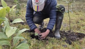
The purpose of this adaptation measure is to support the recovery of natural ecosystems that serve as or contribute to the main water supply sources. It has been shown that vegetation contributes to the retention and regulated disposition of water through horizontal rain capture, infiltration processes, reduction of evaporation, and generation of soil organic matter. Additionally, the ecological restoration measure includes, within its procedure, an environmental planning effort for the territories that not only helps communities identify and/or validate areas of greater importance but also strengthens conservation actions.
Overview
- Location:
- Implementation sites:
-
- Single country
- Single location
- Mountain region:
-
Andes
- Province:
-
- Boyacá
- Site locations:
-
Boyacá/Aquitania/ Vereda Tobal
Boyacá/Aquitania/ Isla San Pedro
Boyacá/Tota/ Vereda La Puerta
Boyacá/Aquitania/ Vereda Hato Viejo
Boyacá/Aquitania/ Vereda Suse
Boyacá/Sogamoso/ Vereda las Cintas
- Solution scale:
- Area Covered:
-
- 1.06 km2
- Ecosystem type(s):
- Other Ecosystem type(s):
-
- Páramo and high Andean forest
- Solution type(s):
- Other Solution(s) type(s):
-
- Ecological restoration
- Sector(s):
- Climate impact(s) addressed:
- Other climate impact(s) addressed:
-
- Soil loss, intense rainfall
- Climate impact time-scale(s):
- Main benefit associated with the solution:
- Co-benefit(s) associated with the solution implementation:
- Sendai targets:
-
-


- SDGs:
-
-
Solution details
Main beneficiaries & outcomes
The greatest benefit derived from ecological restoration is the reduction of climate risk associated with water scarcity during periods of low precipitation.
The main beneficiaries are the families who are part of the rural aqueduct associations. They directly depend on the water captured in the areas where ecological restoration processes are being carried out. This includes Proacueducto Vereda el Tobal (municipality unknown in the original text), Acueducto Ojito de Agua in Vereda Las Cintas in Sogamoso, Acueducto Asoalisal, Vereda La Puerta in Tota, and the Cuarto Alisal, Llanitos, and San Antonio aqueducts in Vereda Suse in Aquitania. An estimated total of 793 families are direct beneficiaries.
Planning and implementation
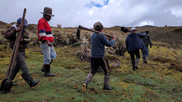
The planning and implementation process was led by the Project on Adaptation to the Impacts of Climate Change on Water Resources in the Andes (AICCA), which is funded by the Global Environment Facility (GEF), implemented by the Development Bank of Latin America (CAF), and executed by the Consortium for the Sustainable Development of the Andean Ecoregion (CONDESAN). In Colombia, the project was executed in conjunction with the Ministry of Environment and Sustainable Development (Minambiente) and the Institute of Hydrology, Meteorology and Environmental Studies (Ideam). Regarding the implementation of actions in the field, these were led by the organizations Corporación Montañas y Bosque Nativo, with significant community participation.
The ecological restoration process aimed at strengthening water regulation can be summarized in the following activities:
- Prioritization of areas of hydrological interest
- Diagnosis of the ecosystem’s degradation status
- Agreement with communities on objectives, goals, and actions to be developed
- Definition and design of treatments
- Formulation of work plans
- Supply of inputs
- Implementation of actions
- Monitoring, evaluation, and follow-up
Regarding project roles, the AICCA Project led the planning and implementation processes for the actions, and the Corporación Montañas y Bosque Nativo was responsible for the on-the-ground implementation of ecological restoration actions. Additionally, the Corporación Autónoma Regional de Boyacá (Corpoboyacá) led the contributions to technical guidance; the Mayoralties of Aquitania and Tota acted as the local facilitator and land owner; and the rural aqueduct associations were the beneficiaries and participants in the planning, design, and implementation process of the actions.
The process of analyzing climate risk in Lake Tota is detailed in the document “Catalog of climate change adaptation measures for the Lake Tota basin”. Climate risks were identified in areas qualified with different indices of susceptibility of adaptation to climate change, through an analysis of variables related to: climate challenges (climate risk and climate change threats) and adaptation capacity (dimensions of biodiversity, water resources, food security and human habitat). The AICCA project has based its analysis on Lake Tota on the Main Ecological Structure model, an axis of environmental management that allows to guide the sustainable management in a specific territory, which considers a spatial, structurally and functionally interrelated system for the maintenance of the regional ecosystem balance. The Lake Tota basin is part of the Support Ecological Structure of the department of Boyacá, and is made up of core areas, transition areas, connectivity corridors and multi-use areas.
Detailed information is available here.
Finance
Project was financed by GEF, through donations. The total cost of the project was 100173 US$. The aqueduct user associations contributed work and labor to the implementation process of the restoration actions.
Innovation
Among the main aspects that can be considered innovative is the use of Climate Risk and Main Ecological Structure analyses in selecting intervention areas and as a sensitization tool with communities to achieve restoration and conservation agreements.
Additionally, several actions were employed to support vegetation growth, including:
• Using nucleation techniques as a planting design.
• Using hydrogel as a water-retaining element for plants.
• Employing shade cloths (polisombras) to protect the most exposed vegetation nuclei from radiation and frost.
• Applying elodea residues to cover the root systems of plants to retain moisture and provide organic matter and nutrients to the soil.
• Installing irrigation systems in the area most sensitive to water scarcity.
Performance evaluation
A performance evaluation has not yet been conducted but is forthcoming.
Long term project sustainability and maintenance
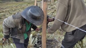
Maintenance activities:
– Review and repair of fences/isolation
– Irrigation application
– Weeding and fertilization
– Replanting
Long-term maintenance costs will be assumed by associations of users of the rural aqueducts.
Capacities for design and implementation
Knowledge
Scientific and local knowledge played a crucial role in the solution. For defining the restoration areas, a spatial integration was performed, including: climate variability and change scenarios, definition of the Main Ecological Structure (MEP), pressures, vulnerability and risk analysis, and hydrological modeling of the Lake Tota basin. This helped determine areas suitable for the implementation of adaptation measures in natural systems, economic activities, and education sectors. Regarding field work, the community’s experience in organizing tasks like loading materials, installing fences, and planting was particularly noteworthy.
Technology
For the design phase, the use of Geographic Information Systems (GIS) was fundamental for data processing and for the development of the Climate Vulnerability and Risk Analyses, along with the Main Ecological Structure. GIS was also crucial in preparing the budgets for the construction work.
Political / Legal
The development of this solution was articulated within the framework of the National Climate Change Policy, specifically aligned with the strategy to manage and conserve ecosystems and ecosystem services for low-carbon and climate-resilient development. Furthermore, within the framework of the National Adaptation Plan, guidelines were established to address planned adaptation, including implementing adaptation measures. Finally, at the local level, the National Council of Economic and Social Policy (CONPES) document, 3801 of 2014, regulates the environmental management plan for the Lake Tota basin. Among its objectives is to increase the development of sustainable productive processes and the diversification of products in the Lake Tota basin. This national framework motivated local teams for the development of this solution and facilitated the justification for its implementation.
In compliance with Colombia’s laws and national policies, the municipalities of Aquitania and Sogamoso acquired properties in areas of hydrological importance, two of which were targeted by the AICCA project with ecological restoration actions.
Furthermore, Law 373 of 1997 mandates the development and presentation of Efficient Water Use and Saving Programs (PUEAA), which water concession users are obligated to incorporate into their commitments with the Regional Autonomous Corporations. In compliance with the requirements adopted in the PUEA, four associations of rural aqueduct users joined the ecological restoration processes in their water recharge areas.
Institutional
The local partners for implementing the ecological restoration measures were the environmental authority, Corporación Autónoma Regional de Boyacá (Corpoboyacá), and the Municipal Mayor’s Office of Aquitania. The coordination mechanism was established through framework agreements for the development of climate change adaptation measures. These agreements defined the commitments of the parties to ensure proper coordination during implementation – which has been successful, allowing for effective engagement with the local community.
Socio-cultural
Within the framework of the project’s governance and sustainability strategy, guidelines were established to initiate co-development spaces with communities and collectively assess specific needs related to climate variability and climate change.
Outlook & Scalability
Barriers and adverse effects
The main barrier to implementation was climatic conditions. Persistent rain and low temperatures posed challenges to working in the intervention areas, such as when installing fences and planting. Subsequently, when the dry season arrived, the lack of moisture and frequent frosts severely affected a significant portion of the planted vegetation.
The solution has certain restrictions, mainly associated with land tenure and land use.
Transformation and future outlook
The validation and recognition by communities of the areas chosen as strategic and of hydrological importance is a fundamental achievement for ensuring water supply. The installation of fences and efforts to restore vegetation are actions that, in the medium and long term, should make a difference in the water supply from their recharge and water catchment areas. It is expected that with the development of the successional process of the plant covers, the water flows associated with the intervened areas will increase and become more stable during periods of low precipitation.
Potential for upscaling and replication
Replicating the solution requires planning and protection of páramo areas at the national level, as well as developing ecological restoration programs in areas that require them. Currently, there are initiatives of this type in various parts of the country, most of which are framed within management instruments such as the National Development Plan, the National Ecological Restoration Plan, the management plans for protected areas at national, regional, and local levels. Furthermore, a significant portion of the regulations associated with water protection also include actions of this type, for example, the Law 99 of 1993, Decree 953 of 2013, Law 1450 of 2011, and Law 373 of 1997, among others.
- AICCA-Colombioa web page
- Catalogue of climate change adaptation measure for the Lake Tota basin.
- Network for phenological monitoring of birds as bioindicators of the effects of Climate Change in the Tota Lake basin, Colombia
- Implementation of a sustainable tourism proposal in the Tota Lake basin – Colombia
- Agroforestry germination center for the recovery and germination of native seeds in the Tota Lake basin, Colombia
Comments
There is no contentYou must be logged in to reply.