Strategy for Integrated Monitoring of High Mountain Ecosystems in Colombia (EMA)
Summary
The objective of this solution is to promote a socio-environmental and multi-scale approach for long-term monitoring of the Claro River Basin, Colombia.
The high Andean ecosystems of Colombia, extending from high Andean forests and paramos to glacier ice caps, constitute dynamic landscapes because of the interaction of climate and land use change in a complex socioeconomic and political context, including new demographic dynamics and policies associated with the peace process and strict regulations for economic activities in the paramos. They are also considered to be among the most exposed and vulnerable socio-ecosystems to the impacts of climate change. There is substantial experience in environmental monitoring of Colombia’s high mountain ecosystems, including programs addressing biodiversity, carbon stocks, hydrology, glaciers, and land use dynamics. However, a conceptual and institutional framework for integrating these diverse initiatives was required (see IDEAM et al. 2018; Llambí et al. 2019).
The strategy for integrated monitoring of high Andean ecosystems in Colombia (EMA) constitutes a national framework to promote a socio-environmental and multi-scale approach for long-term monitoring of the different socio-ecosystems that make up high mountain areas in the country. The objectives of the EMA are:
- Evaluate the dynamics of variables and indicators linked with the ecological integrity, biodiversity, ecosystem services and the wellbeing of the population in high Andean socio-ecological systems in Colombia.
- Relate these dynamics with the main drivers of change operating at different spatiotemporal scales, including climate change and demographic, socioeconomic, and land use change processes.
- Evaluate the effectiveness of the main biodiversity conservation, ecosystem management and restoration strategies, and territorial governance schemes in the country to guide the decision-making process on local, regional, and national scales.
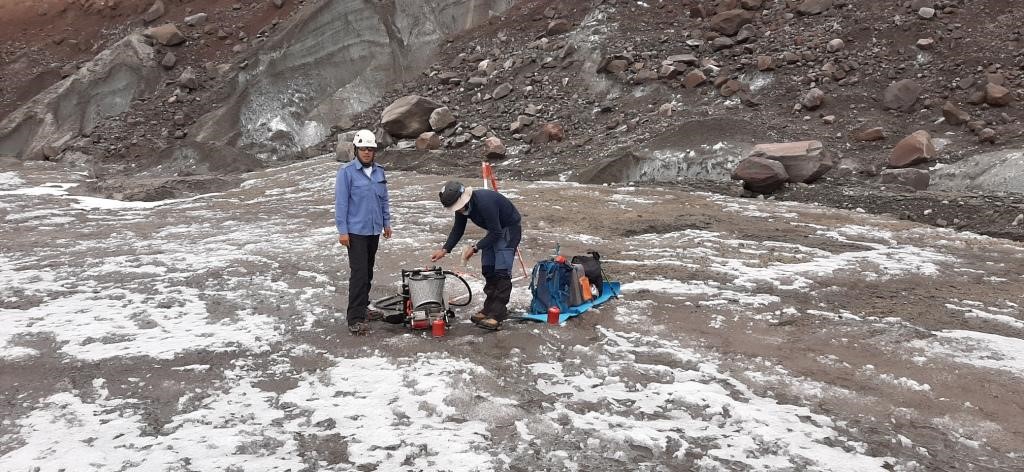
The Claro River Basin, located in the municipality of Villamaría (Caldas), has been selected as a pilot area for the implementation of the EMA, coordinated by the Institute of Hydrology, Meteorology and Environmental Studies (IDEAM) and the Humboldt Institute (IAvH) in collaboration with CONDESAN. The proposed work consists of generating a synthesis analysis of the state and trend of the socio-ecosystems of the area, which include the glacier (Nevado Santa Isabel), the páramo (Los Nevados complex) and the high Andean forest. Likewise, it contemplates the construction of a comprehensive protocol proposal for the monitoring of high mountain socio-ecosystems at the landscape or micro-basin scale. The selection of the Rio Claro basin as a pilot site is due to the extensive experience accumulated in research and long-term monitoring in this basin, where initiatives to monitor the dynamics of climate, glaciers, hydrology, carbon, biomass and biodiversity coincide with land use and ways of life of the local population.
The Rio Claro basin is located inside Los Nevados Natural Park, which has been declared an area of natural interest in 1974. It has an area of 58,300 ha and has heights ranging from 2,600 to 5,321 meters above sea level. In addition to having three of the six remaining glaciers in Colombia (Nevado del Ruiz, Nevado de Santa Isabel and Nevado del Tolima), the park constitutes the most important water reserve in the coffee region, since it supplies 38 municipalities and provides water to more than 3 million inhabitants. The páramo located within the Park has lost part of its territory due to cattle ranching and other changes in land use such as mining.
There are two areas in the basin: 1) the protected area with absolute restriction of uses where only ecotourism, preservation and research are allowed; 2) the complementary conservation strategy with criteria of ecosystem care in the páramo area.
Overview
- Location:
- Implementation sites:
-
- Single country
- Single location
- Mountain region:
-
The Eastern, Central, Western ranges of Colombia
- Province:
-
- The first pilot is being implemented in Caldas province, Central Cordillera
- Site locations:
-
Villamaría municipality
- Solution scale:
- Area Covered:
-
- 583 km2
- Ecosystem type(s):
- Solution type(s):
- Sector(s):
- Climate impact(s) addressed:
- Climate impact time-scale(s):
- Main benefit associated with the solution:
- Co-benefit(s) associated with the solution implementation:
- Implementation timeline:
-
- 2018 - 2100
- Sendai targets:
-
-

- SDGs:
-
-


Solution details
Main beneficiaries & outcomes
The expected outcomes of the EMA are oriented to support informed environmental and social decision-making on the local, regional, and national levels. A technical benefit is the promotion of a more integrated view of high mountain socio-ecosystems in Colombia considering the interactions between different natural and transformed ecosystems, and the interactions between social and biophysical dimensions. Moreover, the monitoring strategy is based on explicitly analysing the main environmental (e.g. elevation) and human transformation gradients and the link between drivers of change (policies, land use practices, climate change, etc.) and the impacts on key response indicators and variables. Another expected benefit is to promote social participation in the implementation of monitoring systems. Further co-benefits will be to provide a basis for the sustainable management of the different high mountain complexes in the country, linking the monitoring programs with the integrated land-management plans for each of this area mandated by law (e.g. the Ley de Páramos 1930).
Key beneficiaries include decision makers, particularly environmental authorities, managers of mountain socio-ecosystems in Colombia and research institutions of the Environmental System in Colombia (SINA) who generate national and sub-national reports and bulletins on state and trends of the environment; practitioners, managers of conservation and sustainable development programs; local communities and their organizations, who will benefit from the information that is being generated but also through their empowerment as active participants in long-term monitoring in these areas.
Planning and implementation
The Strategy for Integrated Monitoring of High Mountain Ecosystems in Colombia (EMA) was born on the one hand from the initiative of several research institutes on monitoring activities in ecosystems and biodiversity, which resulted in the publication of the first version of the strategy in 2018. On the other hand, article 29 of Law No. 1930 of Páramos obliges the Ministry of Environment and Sustainable Development (MADS) to carry out a process of monitoring biodiversity and ecosystem services and implement management and community strengthening actions and productive.
The integrated Monitoring strategy (EMA) has been promoted by the Institute of Hydrology, Meteorology, and Environmental Studies (IDEAM) and the Institute of Biological Resources Alexander von Humboldt (IAvH) of Colombia, with the support of the Consortium for Sustainable Development of the Andean Ecoregion (CONDESAN). The strategy has been designed by a process which has involved:
- Compilation, analysis, and synthesis of technical documents, scientific literature, maps and existing reviews, protocols, and monitoring proposals.
- Electronic questionnaires directed to experts in environmental monitoring programs in Colombia, with emphasis on high Andean ecosystems.
- Face-to-face semi-structured interviews with experts, in which a more in-depth analysis of the existing monitoring programs was carried out, including the aspects mentioned earlier and topics related to information demands from decision makers, lessons learned, spatial and thematic gaps, and opportunities for integration.
- Organization of three workshops to discuss the challenges for integrated monitoring, previous experiences, key questions and variables to include the integration of social and biophysical aspects and the role of participatory strategies.
The EMA is now entering the pilot implementation phase in the Rio Claro watershed (Nevados National Park), under the lead of a consultant team (SIE Ingeniería). A key aspect of this work will be to promote the participation of multiple stakeholders at each pilot site including regional/local environmental authorities, community-based organizations, research institutions active at each site, etc.
Finance
So far, the design of the EMA proposal and the work at the pilot site in Nevados has been financed the Andean Forest Programme and the Adaptation at Altitude Programmes coordinated by CONDESAN with funding from the Swiss Development and Cooperation Agency (SDC). Moreover, the GEF-Alianza Páramo project which is being formulated by the IAvH will work in several new pilot sites for the EMA.
http://documentacion.ideam.gov.co/cgi-bin/koha/opac-detail.pl?biblionumber=38363
http://revistas.humboldt.org.co/index.php/BEP/article/view/699
https://doi.org/10.1659/MRD-JOURNAL-D-19-00020.1
Innovation
The main innovation relates to promoting a more integrated view of long-term monitoring, using a: a) multi-scale approach from the national, to the landscape to the plot level; b) a multi-ecosystem approach that takes into account their interactions along environmental and land-use transformation gradients; c) a socio-ecological approach which considers the relations between livelihood strategies / policies / land-use change / biodiversity and ecosystem services. The other key innovative aspect is the idea of promoting effective participation of local stakeholders in the monitoring process and integrating it with land management plans for each paramo complex in the country and with the process of transformation to low impact production activities in high mountains mandated by the Paramo Law 1930.
Performance evaluation
No evaluation has been conducted yet as the EMA is still starting its pilot implementation phase.
Long term project sustainability and maintenance
The EMA is directly linked with the long-term monitoring strategy of the Ministry of the Environment in Colombia and two of its research/monitoring agencies (IDEAM and IAvH). There is a permanent working group in which both institutions participate specifically for the EMA and mountain monitoring and research teams have been established in both institutions. All of this should contribute to the sustainability of this initiative, as well as the continued support from international funding (e.g. SDC, GEF, etc.). Moreover, the implementation of the EMA strategy is a priority for the official system of environmental research institutions of Colombia (SINA).
Capacities for design and implementation
Knowledge
Documenting, analysing and compiling protocols and results from existing long-term monitoring initiatives has been key to the design of the EMA. In the implementation of pilots, the initial stage involves the generation of synthesis reports on the state and trends of mountain socio-ecosystems. The idea of these reports is to analyse in a more integrated way the available long-term data, strategies and policies and evaluate what has been learned from these monitoring strategies so far and what are the main gaps in knowledge for a more effective decision making and appropriation of this information by relevant stakeholders.
The greatest challenge of the integrated monitoring process is to put the information at the service of the participatory management of the area that goes beyond the scientific entities, in order to establish a dialogue with all the actors and that they appropriate the information and solve the unequal access to information that generates conflicts.
Technology
Many different innovative technologies are part of long-term monitoring in high mountains in Colombia (e.g. high resolution remote sensing data, high elevation hydro-climatological monitoring stations, etc.). What is needed is to more effectively integrate this information, with socio-economic indicators and with an understanding of the relationship between the drivers of change and the impacts on state variables/indicators (i.e. question and model driven monitoring).
Political / Legal
The available policy framework in Colombia has been key to the design and implementation of this solution, specially the Paramo Law 1930 and the 886 resolution from 2018. This regulatory framework explicitly establishes the need to implement participatory monitoring strategies in each paramo complex in the country as part of the definition of land management plans and the evaluation of a process of conversion of production strategies to low impact management systems.
In August 2020, the 58,300 ha of Los Nevados Park were declared by the Superior Court of the Ibagué Judicial District as a special subject of rights for their protection, recovery and conservation with a comprehensive approach. One of the related actions will be to prepare a Joint Recovery, Management, Maintenance and Conservation Plan for the Los Nevados National Natural Park.
Institutional
During the process for the design of the EMA there was a large consultation workshop with the participation of many local stakeholders in the case of the Colombian Cordillera Central. The idea is to continue to implement these strategies for consultation and active participation of local stakeholders in the implementation of the pilot monitoring sites. As mentioned above there is also permanent coordination via a working group between the IDEAM and IAvH and Ministry of Environment for EMA implementation.
Municipalities and departments have an important role to play in the monitoring processes through land use planning. They are included in Law No. 1930 although their role is not clearly defined.
Socio-cultural
There was an initial analysis of stakeholders (Rodríguez 2019) in the case of the Cordillera Central. The implementation of the pilot monitoring sites will involve a more in-depth analysis of local stakeholders and their participation in the design and implementation of long-term monitoring. Moreover, the teams which are leading the implementation of the pilots are from local research/management institutions (e.g. Rio Claro site). The EMA has been conceived as a participatory monitoring strategy, so local stakeholder participation is essential for successes.
There are tensions between national regulations and peasant communities regarding the process of delimiting strict conservation zones and possible productive uses in paramo areas, within the framework of Law No. 1930 of Páramos.
Outlook & Scalability
Barriers and adverse effects
The COVID pandemic has severely limited the possibilities for developing field-work and face-to-face workshops with local stakeholders for the implementation of the pilot monitoring sites. This should be partially addressed via virtual events with stakeholders but for effective participation in the design of the integrated monitoring protocols, face-to-face interactions should be critical in the near future.
Another major challenge relates to the multidisciplinary nature of the EMA strategy and how to guarantee an effective integration of social, economic and biophysic aspects, as well as being able to monitor effectively drivers of change (policies, strategies, economic dynamics) and their impact on response variables/indicators.
Because they are considered as strategic ecosystems in the country (Law 1930 of Páramos), there is a high amount of regulation on the conservation and management of páramos. However, there is still an implementation gap and a challenge to generate greater ownership at the local level. Therefore, the IAvH and IDEAM seek to influence national public policy without creating new policies due to the high number of existing regulations in the country.
Transformation and future outlook
The proposal of the EMA has been important in promoting a more integrated perspective on high mountain ecosystems in the tropical Andes, and in emphasizing the need for more participatory approaches and the value of long-term monitoring for effective decision making. Hence the approach of the EMA has a large replication potential and there have already been exchanges between the EMA coordination team from Colombia and environmental authorities and official monitoring/research institutions working on mountains in other countries (e.g. Peru).
Potential for upscaling and replication
Up-scaling is a key component of the EMA success. The idea is to promote the implementation of pilots of the EMA strategy in many different mountain regions in Colombia. Moreover, the integrated approach of the EMA has the potential to be replicated in other ecosystems in Colombia and in other countries. The EMA is an integral part of the official strategy for environmental monitoring in Colombia (under the responsibility of the research institutions of the National Environmental System, the SINA). Replication has started with funding from SDC in the Rio Claro Watershed and further pilot sites are expected to be implemented with support of the Forests and Páramo project (CHEMONICS) and the GEF-Alianza por los Páramos project (in final phase of formulation by IAvH).
Comments
There is no contentYou must be logged in to reply.