A@A Knowledge Network: How can innovative solutions help close the adaptation gap in mountain regions?

Summary
This International Mountain Day, on the 11th December 2024, the Adaptation at Altitude Knowledge Network (A@A KN) was delighted to host a series of “speed talks” and an interactive exchange on how innovative solutions are attempting to close the adaptation gap in mountain regions. From novel technologies to community-led approaches, learn about the ways in which innovation can manifest in adaptation efforts and why embracing innovation is often crucial in keeping up with the pace of climate change.
This marks the fourth learning event convened by the A@A KN, hosted online by the Stockholm Environment Institute (SEI) under the Adaptation at Altitude programme, which is supported by the Swiss Agency for Development and Cooperation (SDC). The event gathered approximately 40 participants to connect, exchange, and learn from diverse experiences and innovative solutions across mountain regions worldwide.
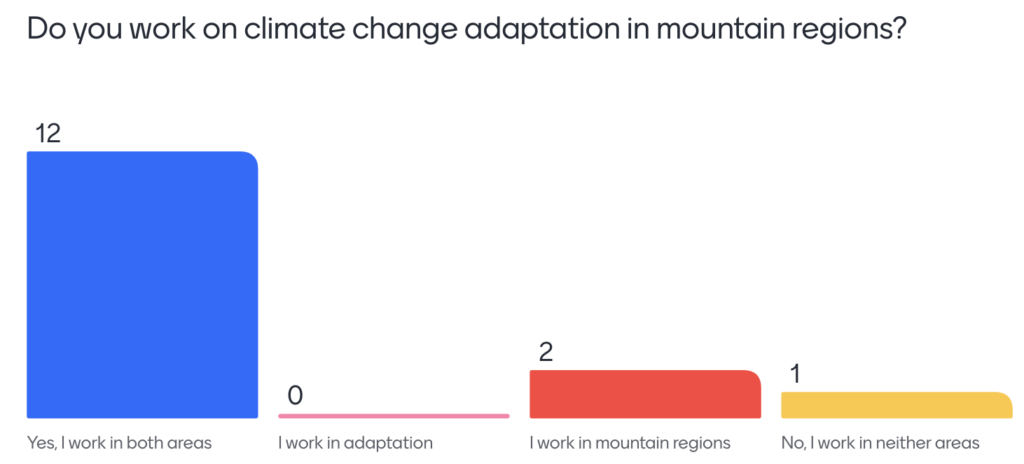
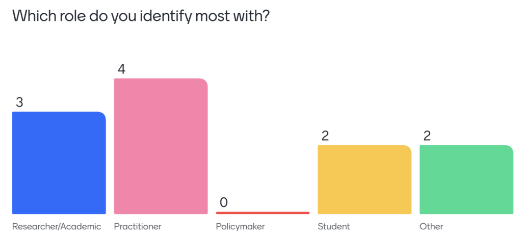
The A@A KN meeting was opened by Rosie Witton (SEI), who provided a brief introduction to ‘innovation’ in the context of climate change adaptation. This was followed by a Mentimeter exercise to better understand the backgrounds and expertise of participants in attendance. For those that participated in the exercise, the majority said they worked on both climate change adaptation and mountain regions (Figure 1), yet through a diverse range of roles (Figure 2).
Kate Williamson (SEI) then introduced the event’s panellists who each showcased an innovative ‘solution’ applied in mountain regions to help build resilience against climate change:
- Dr Upama Ashish Koju, Remote Sensing and Geoinformation Analyst at ICIMOD
- Fuad Bagirov, Azerbaijan Country Representative of the Scientific Network for the Caucasus Mountain Region
- Verónica Quitigüiña, Coordinator of the SEAP Parques para la Vida project executed by CONDESAN
Each ‘speed talk’ was followed by a Q&A, with the event culminating in a wider panel discussion.
What is ‘innovation’?
Innovation can be perceived and interpreted differently, depending on the context in which it is used. Some may equate innovation to ‘new’ ways of adapting to climate change. Whether that be through novel technologies and approaches or finding new ways to collaborate and shift mindsets and behaviours. Alternatively, innovation can also be viewed as shedding light on existing and perhaps lesser-known creative and unique approaches, putting the focus not on ‘reinventing the wheel’, but instead on learning from others and finding new avenues to share and exchange information.
Demonstrating these differences in how innovation is used and perceived, the IPCC AR6 defines systems of innovation as the set of organisations whose activities and interactions generate, modify, and deploy new technologies, whereas the Adaptation Fund defines innovation as the creating, testing, and deployment or diffusion of new, adapted or improved adaptation solutions that have been developed contextually and with the inclusion of communities most vulnerable to climate change.
Additionally, when looking even further into innovation, it can be divided into three categories:
- Incremental innovation = marginal improvements on existing approaches or technologies;
- Breakthrough innovation = significant improvement with potential for widespread change; and
- Adaptive innovation = focuses on using and adapting existing approaches in new ways and new contexts.
But to what extent do we need innovation in adaptation and to what extent do we have existing solutions that we need to enhance, contextualise and learn from? COP29, again brought innovation into the limelight through discussions on transformational adaptation. The UN Framework Convention on Climate Change National Adaptation Plan task force indicated that the shift towards long-term transformational adaptation, systems change and holistic approaches can facilitate the integration of scientific and technological innovations with traditional and Indigenous knowledge. But how do we go about doing this in practice and at the pace required?
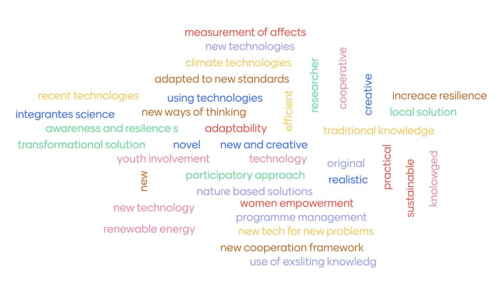
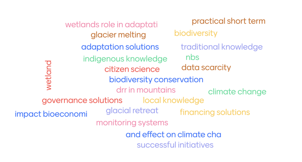
This event explored what innovation means in the context of climate change adaptation solutions implemented in and designed for mountain regions. When asked ‘what makes a climate change adaptation approach innovative?’ (Figure 3), participants highlighted the need for new technologies; new and creative ways of thinking; participatory approaches and those that integrate local and traditional knowledge; empowerment of youth and women; and practicality and adaptability.
Managing forests for climate resilience in Nepal
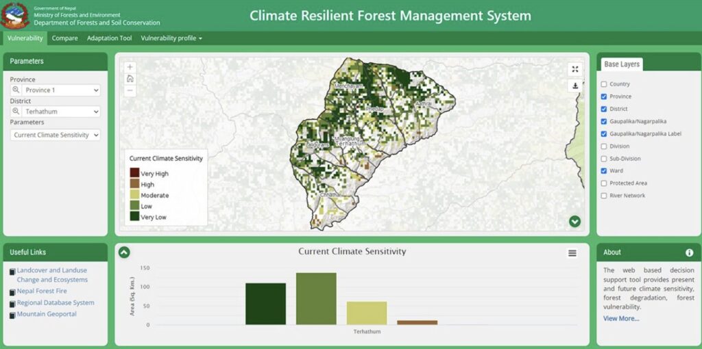
Our first panellist, Dr Upama Ashish Koju, introduced the work being done by the International Centre for Integrated Mountain Development (ICIMOD) on managing forests for climate resilience in Nepal.
The issue – climate change and unplanned developments are causing forest to degrade rapidly, in turn also enhancing their vulnerability to future threats. With 45% of Nepal being forested, it is critical that forest management approaches prevent and respond to these impacts to support both climate change mitigation and adaptation efforts. Yet, such approaches are hampered by the limited availability of precise information and data on forest degradation and vulnerability across the country.
Solution – ICIMOD, as part of the SERVIR/HKH Initiative, have developed ‘The climate resilient forest management system’ (CRFMS): an open-access tool that provides user-friendly information on i) climate sensitivity; ii) forest degradation; and iii) forest fire risk, for all 77 districts across Nepal. The tool also considered gender and social inclusion to ensure the tool supports the most vulnerable. Users can compare, for example, vulnerability data with forest fire or degradation data to identify potential patterns and trends. Overall, the CRFMS aims to support forest managers make decisions and plan in the context of current and future risk. This is done in tandem with an adaptation toolkit, in development with government officials, to help identify the msot effective interventions based on the available data.
Method – the CRFMS uses satellite datasets to assess and quantify changes in Nepal’s forests. Individuals were also pro-actively engaged in developing the tool to ensure its effective use in decision-making and planning activities.
Success factors and impact – the solution relies on robust data sources as well as effective coordination between stakeholders at national and local levels – the latter, also important for monitoring the tool’s use and impact. The CRFMS follows a “Science into Use” approach, emphasising the bridge between data and policy and practice. The tool can be replicated to mountainous regions within and beyond the HKH region.
Tackling water scarcity: Gajimarda village rehabilitation project
Our second panellist, Fuad Bagirov, highlighted how the Gajimarda village in Azerbaijan is adapting to the impacts of climate change through rehabilitating water infrastructure.
The issue – Azerbaijan is experiencing greater pressure on its water systems as a result of climate change. Prolonged dry spells and periods of heavy rainfall are affecting crop yields and thus the wider economy. Moreover, the irrigation systems are aging and are not sustainable long-term in adapting to the impacts of climate change.
The solution – the Gajimarda community have partnered with local authorities to rehabilitate the village’s irrigation system and increase its climate resilience. This has entailed cleaning and repairing the reservoir to prevent water leaks, replacing metal pipelines with plastic ones and adding 23 new water distributors, and building tap points for drinking water access. Additionally, to further ensure its long-term sustainability, the Astara Rayon Irrigation System Department has provided training to the community on how to maintain the irrigation system. This is important given that the community has contributed financially to the new system, fostering a sense of collective ownership.
Success factors and impact – to be successful, the solution required effective public-private partnerships and coordination, as well as inclusive management. As a result, it has directly benefited 2,146 residents from across 180 families by helping to reduce the risk of water scarcity and revive the horticulture economy. It has also helped to empower women to actively engage in agriculture and market activities. This type of approach can be readily replicated in other mountain regions facing issues of water scarcity.
The Gajimarda project offers a scalable model for other mountain regions or water-scarce areas. Its success demonstrates the power of community-led initiatives supported by local authorities and tailored to regional climate challenges. By fostering partnerships and promoting inclusivity, this approach can strengthen climate resilience globally.
Analysis of the Machángara river sub-basin under the landscape approach as an adaptive management strategy for water resources and climate change
Our third panellist, Verónica Quitigüiña, showcased the work of the Adaptation to Impacts of Climate Change on Water Resources in the Andes (AICCA) project and highlighted the importance of a landscape approach in integrating science, governance, and sustainable practices to achieve resilience and sustainability.
The issue – water resources are increasingly threatened by climate change, as well as human activities, such as land-use changes and deforestation. The main challenges in the Machángara sub-basin in Ecuador include plantations, road constructions, weak governance, unclear land tenure, and inadequate water use policies.
The solution – the study applies a landscape approach to analyse the Machángara River sub-basin and develop technical guidelines for its sustainable management. It has three specific objectives: i) analyse landscape dynamics – understand the spatial and functional configuration of the basin to maintain ecosystem functionality and water production; ii) enhance connectivity – identify key areas to support biodiversity and ecosystem processes; and iii) develop sustainable guidelines – create actionable plans that link territorial planning with ecological integrity.
The method – the study assesses land use and vegetation coverage using remote sensing satellites – and of the 39 types of land uses and vegetation coverage, 17 landscape elements were defined. This is followed by landscape analysis, which considers vertical (e.g. topography), horizontal (e.g. connectivity), and transversal (e.g. direct and indirect drivers of change) dimensions. This solution is innovative in that it views the landscape as a socioecological system where natural and human components interact dynamically. This is seen as crucial in harmonising human activities with ecological sustainability and thus ensuring that resources remain available for future generations.
Success factors and impact – the study highlighted the importance of the ‘Paramo’ ecosystem: highland grasslands in the Andes, that cover the largest and most connected patches, in turn supporting biodiversity and water production processes. Future land management approaches must therefore avoid fragmentation and maintain ecosystem connectivity. Potential adaptation actions in this regard include restoration to help rehabilitate degraded forest and water bodies; eco-friendly agricultural and grazing methods; and improving local capacity and policies that support sustainable resource management. Looking forwards, the focus will be on scaling the study’s method and approach to other regions, enhancing community participation, and improving resource management policies.

Q&A
How do you think your solution contributes to new ways of thinking and this idea of ‘transformational’ adaptation?
- Dr. Upama emphasised the role of the CRFMS decision-support tool in influencing policy, and encouraged interventions to take into account future climate change scenarios. Additionally, she highlighted the role of data and technology in advancing adaptation solutions and influencing policies long-term.
- Fuad raised the importance of public-private partnerships in decision-making processes, as well as increasing the involvement and active participation of the community.
Can these types of projects be easily transferred to other mountain regions? If so, what factors can help replicate and upscale these solutions?
- Dr. Upama noted the need for open-source data platforms, since these were key in developing the framework. They initially piloted the tool in three districts before extending it across Nepal, and have plans to apply the tool across the HKH more broadly.
- Fuad mentioned the role big programmes can play in issuing small grants and helping mountain regions implement and scale-up adaptation projects.
What advice would you give to people wanting to design adaptation strategies at a landscape level or at a cross-border scale?
- Verónica emphasised that implementing a landscape approach requires time and that it can often take years to see the impacts of adaptation practices. So the best advice is that people have to be a little patient!
How do you think these types of solutions can be innovative in keeping pace with the effects of climate change?
- Dr. Upama noted that disasters are happening more unexpectedly, and that, although not a cure for all, geospatial tools can be one approach to help adapt to rapid onset climate change impacts. For example, their forest fire portal alerts subscribers to where fires are occurring across Nepal to help people act and respond accordingly.
- Fuad also mentioned the need to take into account the varying impacts of climate change across a region and the different local contexts when selecting appropriate adaptation responses.
Want to get involved?
The A@A Knowledge Network is hosted on the Climate Change Adaptation in Mountains theme on weADAPT – a place where all are welcome to share their knowledge, and learn from and connect with others working on climate change adaptation in mountains. Find out more about the Adaptation at Altitude (A@A) Knowledge Network here.
You can also highlight your work in an open access database on adaptation solutions for mountains: the Adaptation at Altitude Solutions Portal.
Below are some of the topics you’d be interested hearing more about to support your work on climate change adaptation in mountains. Have more? Get in touch at: adaptationataltitude@zoinet.org.
Further resources
A@A Knowledge Network: Co-creating and Integrating Local Knowledge in Mountain Adaptation Solutions
A@A Knowledge Network: Designing and implementing transboundary adaptation in mountains

A@A Knowledge Network: What does 2024 hold for mountains and how can you get involved?

Comments
There is no contentYou must be logged in to reply.